
Active WD likely to trigger widespread moderate rain, snow during next 4 days over J&K: IMD
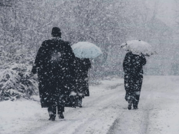
A fresh active Western Disturbance (WD) is most likely to trigger widespread moderate rain and snow during the next four days over Jammu and Kashmir, officials said.
The WD is likely to hit Tuesday evening, and under the influence of this weather system, widespread moderate rain or snow and thunderstorms are expected in most places in Jammu and Kashmir till February 28, the Indian Meteorological Department (IMD) said on Tuesday.
It said light to moderate rain/snow would first commence over places of North and Central Kashmir on February 25 (evening/night) and thereafter gradually increase in intensity and distribution throughout J&K.
The system will most likely to cause moderate to heavy snow mainly in middle and upper reaches of Kashmir Division including Gulmarg, Sonamarg, Baramulla, Bandipora, Gurez and Tulail Valley, Kupwara, Machil and Tangdhar Sector, Shopian, Pir Ki Gali, Qazigund-Ramban axis, Doda, Kishtwar and Pirpanjal Range of Jammu Division during the period.
There is a possibility of isolated heavy to very heavy snow over a few higher reaches of South Kashmir and Chenab Valley during February 27 and 28.
The IMD has also issued an advisory stating that this weather system may lead to disruption of surface and air transportation like National Highway Srinagar-Jammu, Sadhna Pass, Razdhan Pass, Sonamarg-Zojila Axis, Sinthan Top & Mughal Road, etc. All tourists, transporters, and travellers are advised to plan their trip accordingly.
It has also warned that the middle and higher reaches of Kashmir and the hilly area of Jammu are most likely to receive moderate to heavy snowfall, while a few higher reaches of South Kashmir and the Chenab Valley may receive heavy to very heavy snowfall, particularly on February 27 and 2.
Farmers have been advised to suspend irrigation and other farm operations during the period.
There is a possibility of landslides/shooting stones/mudslides at vulnerable places also.
The day temperature is likely to witness significant fall due to the inclement weather in Jammu and Kashmir.
The night temperature increased at most weather stations of the Kashmir valley with Srinagar recording a minimum of 4.9°C and it was 3.1°C above the average for the summer capital of Jammu and Kashmir during this period of the season.
The day temperature recorded in Srinagar on Monday was 18.0°C, and this was 7.0°C above normal for the place.
The ski resort of Gulmarg recorded a low of -1.3°C and it was 4.3°C above normal while the tourist resort of Pahalgam had -0.3°C and it was 2.3°C above normal for the valley of shepherds in south Kashmir.
👉Join JK Updates WhatsApp Channel 👈
Job Recruitment in CRPF Jammu , Check Details
21413 Gramin Dak Sevak Posts, Apply Now
1,194 Posts: SBI Recruitment 2025, Apply Online