
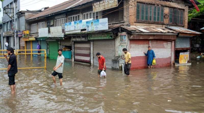
J&K Rain Live Updates: Jhelum reaches flood alert level
Rain Effect Updates from J&K
Jhelum reaches flood alert level of 18 ft. at R.M Bagh, Srinagar; I&FC officials asked to report immediately, public urged to stay away from rivers and streams.
*Update 7:30 pm*
The water level of Chenab River at Akhnoor has once again crossed the Flood Alert Level
Present Level: 33.0 ft.
Alert Level: 32.0 ft.
Danger Level: 35.0 ft.
Tawi at Udhampur crosses Flood Alert Level at 12:30 pm ⚠️
Tawi River has risen by more than 6.65 ft in just 30 minutes.
🎓 Explore Jobs by Qualification
Explore the latest job opportunities in J&K and across India based on your educational qualification.
Current Level: 16.65 ft.
Alert Level: 15.0 ft.
Danger Level: 20.0 ft.
Evacuation Level: 23.4 ft.
*Rainfall recorded till 9:0 a.m. (Previous 24 hrs)*
*Kashmir Region:*
Srinagar = 15.6 mm
Qazigund = 73.3 mm
Pahalgam = 60.2 mm
Kupwara = 6.9 mm
Kokernag = 47.9 mm
Gulmarg = 39.0 mm
Pampore = 20.0 mm
Srinagar Airport = 9.8 mm
Awantipora = 31.2 mm
Anantnag = NA
Pulwama = 14.2 mm
Budgam = NA
Ganderbal = 18.0 mm
Sonamarg = 13.0 mm
Baramulla = 30.5 mm
Bandipora = NA
Shopian = 17.0 mm
Kulgam = 24.2 mm
Khudwani = 48.0 mm
Sangam = 37.0 mm
Asham = 12.0 mm
Wular = 14.0 mm
Batkoot = 43.5 mm
Verinag = 35.3 mm
Babapora = 15.1 mm
Charar-i-Sharief = 6.6 mm
Tangmarg = 22.2 mm
Sopore = 12.0 mm
Nowgam Handwara = 18.6 mm
Lolab = 16.4 mm
Bumhama Kupwara = 16.2 mm
*Jammu Region:*
Jammu = 60.6 mm
Banihal = 53.0 mm
Batote = 60.4 mm
Katra = 97.4 mm
Bhaderwah = 14.0 mm
Kathua = 22.2 mm
Jammu Airport = 42.6 mm
Udhampur = 53.2 mm
Ramban = 71.5 mm
Poonch = 11.0 mm
Kishtwar = 12.0 mm
Rajouri = 32.6 mm
Reasi = 119.5 mm
Doda = 15.0 mm
Samba = NA
*Ladakh:*
Leh = 0.6 mm
Kargil = NA
Compiled By: Kashmir Weather
Jammu-Srinagar NH-44, Doda-Kishtwar Road Shut Following Landslides, Heavy Rainfall
*Rain, floods wreak havoc; Chenab, Ujh flow above danger mark, alert sounded*
* 2 die, 4 hurt as boulders fall on Tempo in Ramban
* Jammu-Srinagar NH, several other roads closed
A moderate spell of rainfall was recorded in some areas of south Kashmir during the last 12 hrs. Hence the upward rising trend of Jhelum is expected to continue today.
*Breaking:*
*Update 7 pm:*
Lidder River (major tributary of Jhelum) has reached the Flood Declaration Mark
Current Level: 1.55 m
Flood Declaration Mark: 1.5 m
Danger Level: 1.65 m
*Rainfall Recorded during last 9hrs over Jammu and Kashmir*
*Kashmir Region :*
Srinagar = 13.0 mm
Qazigund = 33.2 mm
Pahalgam = 16.6 mm
Kupwara = 6.5 mm
Kokernag = 32.2 mm
Gulmarg = 35.0 mm
Gulmarg AWS = 32.0 mm
Baramulla = 30.0 mm
*Jammu Region :*
Jammu = 47.0 mm
Banihal = 37.2 mm
Batote = 35.6 mm
Katra = 91.4 mm
Bhaderwah = 9.0 mm
Reasi (SMVD) = 109.0 mm
Reasi = 94.5 mm
Ukhral Ramban = 58.5 mm
Bakore = 50.5 mm
Jammu Airport = 48.0 mm
Govindpura Ramban = 43.5 mm
Rajouri = 36.0 mm
Rajouri ARG = 30.5 mm
RS Pura = 26.0 mm
Data = IMD Srinagar
Compiled By : Kashmir Weather Forecast
Jhelum Water Level Well Below Warning Mark, No Need to Panic: Flood Control Department
Update 3:30 pm: Water Level of Chenab River at Akhnoor Reaches Danger Mark
Current Level: 35.0 ft.
Alert Level: 32.0 ft.
Danger level: 35.0 ft.
Evacuation Level: 42.0 ft.
*South Kashmir Alert*
Very heavy rain is continuing across South Kashmir and is expected to continue until the current weather system weakens.
The continuous rainfall will likely cause a rapid rise in the water level of Vishow Nallah and other rivers and streams over the next few hours. People living near rivers, nallahs, and low-lying areas are advised to stay alert and avoid unnecessary travel.
Regards: Kashmir Weather Forecast
Jhelum swells, likely to cross flood warning level in coming hours as IMD forecasts heavy rain till evening.
*Weather Situation Critical Across J&K Today, Improvement Expected From Tomorrow: Sonam Lotus*
Ladakh: Fresh snowfall at Wari La and Pensi La Pass, motorists advised caution.
*8 missing bodies in Surankote flash floods remain untraced*
* Old Samba-Kathua road washed away in flood
* No power, water supply in Poonch since Sunday
Beerwah’s Sukhnag diversion washed away; bridge damaged after flash flood
Big Breaking: Ujh River at Panjtirthi Kathua has crossed the Evacuation Level
At 3 pm
Level: 24.0 ft.
Alert Level: 16.5 ft.
Danger Level: 20.0 ft.
Evacuation Level: 23.5 ft.
Present Status: Increasing
Kathua has been battered by torrential rain, recording 93.5 mm of rainfall within just 3.5 hours.
Ujh Nallah at Panjtirthi (Billawar Kathua) has crossed the Alert Level of 16.5 feet at 12 pm
The water is approaching the Danger Level
Present Level: 19.0 ft.
Alert Level: 16.5 ft.
Danger Level: 20 ft.
Evacuation Level: 23.5 ft.
Following the recent heavy rainfall in Kathua district, the Old Samba–Kathua Road at Sahar Khad near Sherpur has been breached once again due to flooding.
Heavy flooding is currently being witnessed in both the Sahar Khad and Magar Khad.
Additionally, several streams across Kathua district are showing a sharp and rapid rise in water levels.
*Heavy Rain Forces Opening of All Salal Dam Gates; Public Advised to Stay Away from Chenab*